On a bright summer day in 2013, a prospective research student from Canada stepped off a bus in a north Highland town, guitar in hand. The next three years impacted, not just on his life, but on those of the historians who would supervise him.

Like most academics at my stage, I’ve supervised a few PhDs. It’s a serious responsibility as the experience is often life-transforming for the student. I now see that the ‘Royal Dornoch PhD Studentship’ at the University of the Highlands and Islands has had a profound effect on my own work too.
There was some ‘prehistory’ to this. Since 2008, I had begun a conscious move towards the coast in my historical research. It was only from 2011, however, that a new possibility emerged. I became Head of the university’s Centre for History that year and was perhaps keen to make my mark in that position. Serendipitously, Neil Hampton, manager of Royal Dornoch Golf Club, and several of his colleagues, visited our Centre to let us know that the club would be celebrating ‘400 Years of Golf in Dornoch’ in 2016. Would we like to be involved? If so, what could we offer?
I jumped at the chance. With assistance from Centre colleagues, things advanced quickly. We created a proposal. Further chats and emails, and the extremely generous support of the club and the university’s Development Office, put the financial support in place. By the spring of 2013, an advert had gone out, interviews were complete, a contract signed and the guitar-playing Canadian, Wade Cormack, was preparing to wing his way over from Toronto Pearson to Inverness Dalcross.
The golf club hosted a hugely successful launch. Leading professional golfer, Paul Lawrie, was kind enough to attend, the events filmed for BBC News and broadcast on Reporting Scotland that evening. The university’s Communications and Marketing team worked hard and supportively with us too, while there were features also in the national newspapers and additional media attention back in Wade’s home country. It was a fine start.
Once Wade commenced the research proper on 1 September, the club were keen to keep his profile high. They encouraged him to meet as many of the donors as possible, to write a regular blog and to deliver annual lectures and other talks to members.

Each of the three academic years to follow was action-packed, but if I were to single out one, it would be 2015-16, during which Wade:
- collaborated with staff and pupils at both Dornoch Academy and Dornoch Primary School to create a project on the history of golf fashions as well as a wonderful series (and subsequent exhibition) of artistic renderings of the town’s sporting past;
- travelled to North Carolina and New York to speak, respectively, at the prestigious Pinehurst and St. Andrews Golf Clubs;
- presented at the Captain’s invitational event in Dornoch;
- was the main speaker at a gala dinner on Dornoch links, attended by several hundred, and which attracted members of ‘Royal’ golf clubs from across the world.

Wade’s alma mater, at Guelph, remained interested, and, as if 2015-16 wasn’t busy enough already, he delivered the second of two lectures at the ‘Scottish Roundtable Lecture Series’ hosted by the Centre for Scottish Studies there. He also spoke to the Rotary Club of Inverness, presented a paper at the annual British Society of Sports History conference in Swansea, and sneaked in another talk at the Centre for History’s annual postgraduate research day in Dornoch.
It all seemed a long way from the more solitary joys and challenges of archival research and writing I had experienced as a PhD student. As his supervisors, we sometimes worried about the pressures on Wade. Doctoral students are human beings. In retrospect though, in Wade’s case, we perhaps needn’t have fretted so much. All the activity proved, as planned, to be complementary and, dare I say it, even enjoyable. Through regular meetings, the setting and re-setting of timetables, detailed and, I trust, prompt enough commentary on his work, the presentation of monitoring forms to the university’s Research Degree Committee and of annual reports for the two funding bodies, we were able to keep a close eye on how things were going.
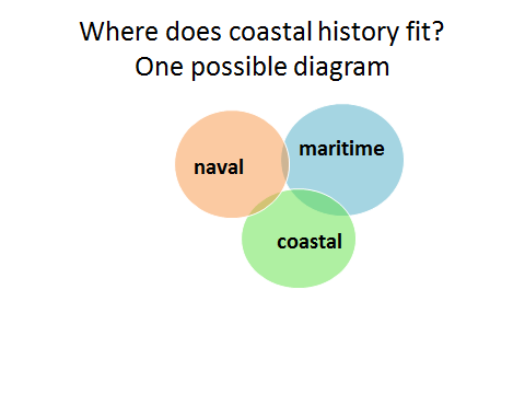
The intellectual traffic between a PhD supervisory team and their student is sometimes seen as one-way. It seems strangely uncommon for supervisors to comment on how the experience informed their own work. Wade’s findings influenced my writing of two new Coastal History articles, encouraged me to lead on the development of a taught postgraduate module, ‘Sport in Highland History’, and helped the Centre cement its place in Dornoch via the ‘Firths and Fjords’ conference in spring 2016, thereby providing some background to the distance-learning MLitt Coastal and Maritime Societies and Cultures, which we will launch in 2017.
Wade had his oral examination in October 2016. He has since submitted, and had accepted, his final hardbound thesis. As early as 2015, he had published an article in Sport History. But his external examiners have expressed their keenness for him to convert the thesis to book form. I agree wholeheartedly.
Thirty-eight months after the PhD commenced, I’m hugely impressed with everything Wade’s achieved. He was already a self-motivated researcher and a strong communicator the day he stepped off that 25X bus. But he did develop an additional skill set: a much greater ‘tightness’ in his writing, and an impressive thoroughness, rigour and clarity when it came to researching and presenting on early modern Scottish sport history. Out of all this he produced an excellent PhD thesis. Not only that, but he rose to the myriad challenges and opportunities of finding himself in a totally new working and living environment. For all of this, he, his parents, friends, the club, the Centre for History and the university have cause to be proud.


 Dornoch, Scotland, 31 March 2016

 It was a great pleasure to attend ‘Firths and Fjords’ in Dornoch. As a non-historian, I appreciated the chance to view the coastline from a historian’s multi-layered, multi-disciplinary perspective, and I have found myself referring back to the many interesting, detailed presentations since. This week I attended the